Astronauts have taken over a million photographs of Earth from the International Space Station. Many of them have been taken at night, like this one of Berlin:
 |
| Berlin at Night from the ISS, original image ISS035-E-17210 available here. |
A group of ISS photo enthusiasts and light pollution researchers have solved your problem by putting together an Atlas of nighttime images of the Earth. This post is a short note to help you use a feature of the Atlas that's not necessarily very obvious from the main page.
When you go to the main page, scroll down to "Gallery of cities at night". Here you can scroll and zoom over the Earth to find a city (like Calgary). When you click on the dot, it will pop up some information about the photo, as well as a thumbnail:

The thumbnail has a link to the photo at the NASA gateway - but if you click on it you'll notice that it's not the one that Commander Hadfield tweeted! The problem is that multiple photos of Calgary have been taken.
While the Atlas website is super for finding cities that have been imaged, it's not what you want to use if you're looking for all photos of a given city. To do that, you want to click below where it says "Original at http://www.nightcitiesiss.org."
When you click there, you will get to a google spreadsheet that looks like this:

Now click on "Table of data" near the top left, type the city you're looking for in the box at the top left, and then click "Find":

The last step is to scroll down on the NASA page to the two "view" buttons. Click on the bottom one:

and voila, here is your full resolution image:
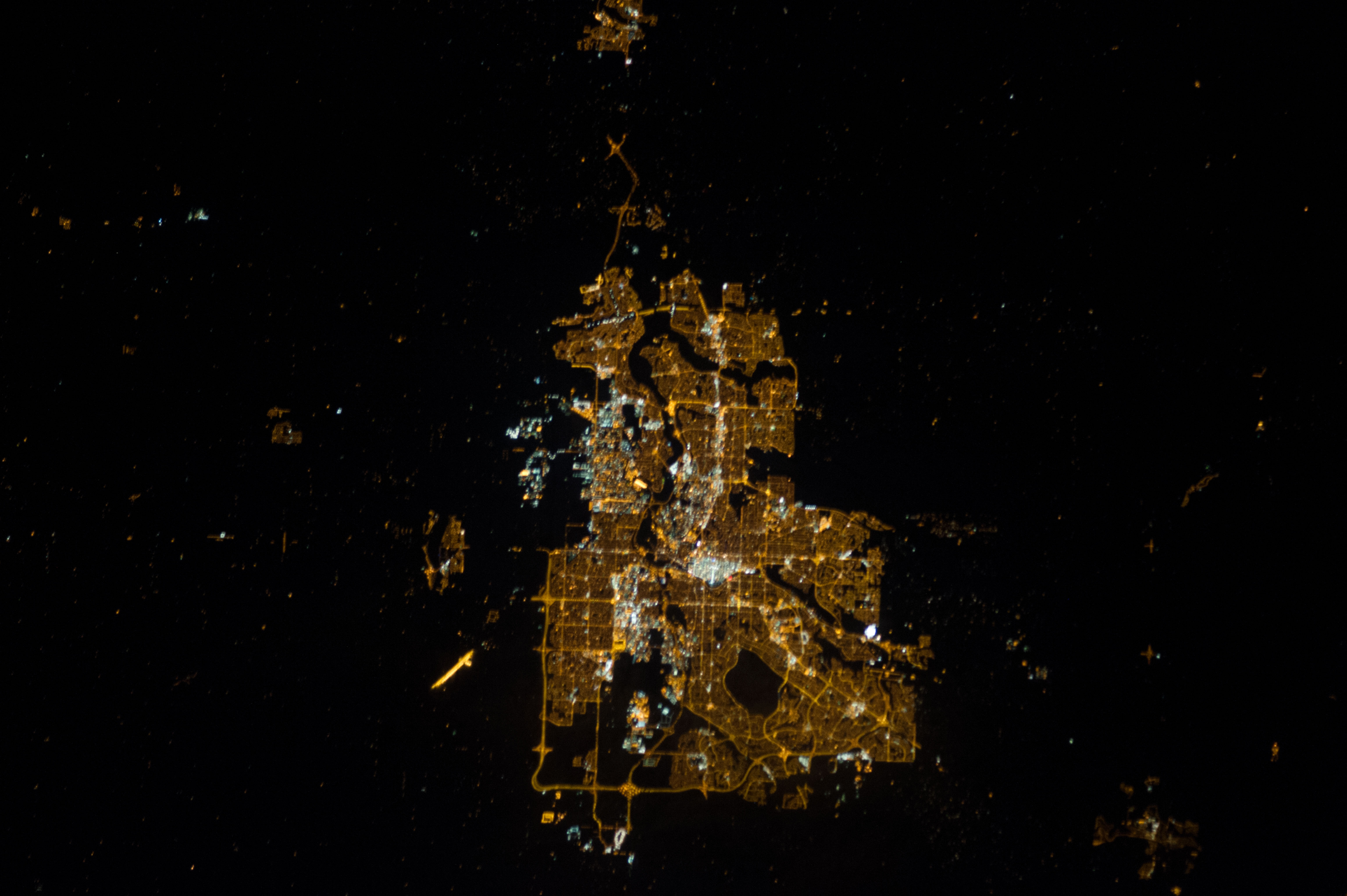 |
| Calgary at Night from the ISS, ISS034-E-44268 |
The images from the NASA site are all free to use, provided you acknowledge the photo source (there is a recommended citation at the bottom of the page). To make it easier for other people to find the photo in the future, be sure to always include the image designator that starts ISSxxx.
If you use the Atlas to find a photo and then publish the photo somewhere, then please also cite this paper: Alejandro Sánchez de Miguel, et al., Atlas of astronaut photos of Earth at night, Astronomy & Geophysics, Vol. 55 no4. August 2014 (in press).
Going forward
The best part about the Atlas website is that it includes three citizen science projects to ensure that future photos are cataloged, and to find other older images "hidden in the dark of the database".
Dark Skies of ISS allows citizens to sort images between different types: Images of cities, images of stars, and other images. It requires no previous knowledge, and is only available online. It is the simplest of the three projects.
Night Cities aims to allow citizens to apply their lay knowledge of local and international geography. The project shows paired images of cities with maps. Project volunteers identify points in the night images and match them to positions on the maps. With this help we can generate light maps of cities.
Lost at Night is the stiffest challenge for citizens with good geographical knowledge of a region. Their goal is to identify which city is in an image without any identification. The position of the cities in this case is only known to within about 500 km.
Note: If this is your first-ever visit to the blog, welcome! The blog is about a citizen science app called "Loss of the Night". We need your help to understand how changes in street lighting technology are changing the night sky. You can read our introduction to the blog here, and instructions on how to use the app here.
There's lots more to see, including:
- photos of great parking lot lighting from Germany
- photos of terrible street lighting from Spain
- photos of how searchlights look to migrating birds
- proof that your eyes have no idea how bright your computer screen is
- news about our "Flashmob for Science" events
Hi, there used to be 4 photos from Ottawa, Canada, that I could find using your instructions from the paper in Remote Sensing (just a few months ago). Now I can only find one - and it happens to be the only one partially affected by haze. What happened? How do we get the others back? There were clearly already correctly identified as being from Ottawa!
ReplyDeleteSorry that these instructions are out of date, I haven't had a chance to re-write them, but it's on my to do list. Try the cities at night gallery first: http://www.citiesatnight.org/#gallery and if not there then scroll down to the "catalog". If you can't find it in either of them, then try the tables here: https://www.google.com/fusiontables/DataSource?docid=1sxKXrg4yfmMO8Ok61UDOS_dkLc24Vj3_iHhibi4T#map:id=3
DeleteIf none of those work, then email me and I'll put you in touch with the cities at night team. My contact information is here: http://userpage.fu-berlin.de/~kyba/